Create a Map
Add a new map to the current database. A map is comprised of one or more faces oriented around a cube of specified dimensions.
You can create one of two map types:
-
A face map—one or more faces representing underground face features, channel samples and other supporting items. Maps form one or more parts of an open cuboid (that can be expanded into a butterfly view if required).
See Create a Face Map.
-
A level map—also referred to as a 'back' or 'area' map, is a commonly employed mapping methodology which involves capturing geological & structural data observed in the roof (back) of underground excavations.
A map type is associated with an entry in the Map type list of the New Map screen, the contents of which depend on the type of that is associated. For example, defining a face map involves setting which faces of the open cuboid are to be mapped, whereas a level map requires a reference level coordinate (Z) and the size of the rectangle that will ultimately host the level map.
Opening the screen will fill out the Map name automatically if your configuration file contains a naming convention, otherwise, it will be blank and a name must be entered. See System Configuration File.
Face Maps

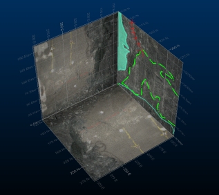
An example of a face map (unexploded view) in Studio Mapper
In Studio Mapper, a face map is presented as one or more faces of an open cuboid. Face maps can be local or georeferenced, and are typically prepared for field data reports.
Face maps are typically of a smaller scale than level maps (see below) and are commonly the work of a single field geologist. Data is mapped onto each face of a cuboid that is relevant to the field mapping campaign. These faces are defined for each map type in the XML configuration file.
Face maps can be 'exploded' into a butterfly map view for ease of multi-face digitizing and visualization. An exploded view, can make it easier to map the intersect of a structure across multiple faces, for example.
Level Maps
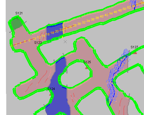
A level map showing cumulative back mapping and tape line
Back mapping, also referred to as level or area mapping, is a commonly employed mapping methodology which involves capturing geological & structural data observed in the roof (back) of underground excavations. Geologist’s employ this workflow in steeply dipping ore-bodies to interpret the orientation of ore-controlling structures, which in turn helps with better stope design and production planning.
A common approach to mapping for steeply dipping ore bodies, these maps can represent a level, drive or development. Studio Mapper supports all of these resolutions of data. Larger-scale, level-based maps may consist out of a collection of smaller maps which are captured over time, often with multiple contributors.
Apart from having a fixed scale, level maps may also have clear definitions on coordinate bounds. Underground operations usually employ a mine-wide grid which divides areas up into distinct “blocks” which is defined by min/max coordinate bounds. Level maps are frequently defined by such grids, and as such, defining a level map in Studio Mapper requires these bounds to be defined up front.
Field data is commonly geolocated using milestone data such as survey strings and survey station locations. Field-gathered data can either be draped to a constant elevation, or using Studio Mapper's unique 'drape to survey'routine, to the shape of the back implied by the survey point or string data.
Level maps need to present the intersects of contacts and structures, often captured with dip and dip direction data.
Studio Mapper supports the following level mapping workflow, although there's no rigid application and this can be adapted to your own method of working:
-
Survey data is cleaned and prepared.
-
A new level map is created. See Create a Level Map.
-
Survey data is imported.
-
A grid is applied.
-
Feature data is captured and draped onto the survey data, or a flat plane.
-
A PDF report is created.
How does level mapping differ from face mapping?
-
Level mapping requires external survey data to define the mapping profile and orient features.
-
Mapping is performed directly into real-world space, without a separate georeferencing function.
-
Level maps typically involve larger dimensions than face maps, and include undulating profiles.
-
Maps are borne from numerous observations or underground visits by more than one contributor.
-
Output PDF reports are all in plan projections at a pre-determined scale.


